Tuesday, February 23, 2021

Last Pole Shift 42,000 years ago was a Climate Catastrophe and Mass Extinction Event

A new analysis in Science has turned upside down the theory that a reversal of the earth's magnetic poles had a minimal impact upon life on earth. By studying the rings of giant kauri trees thousands of years old in well preserved in bogs in New Zealand scientists from the South Australian museum and the University of South Wales found that the last pole shift 42,000 years ago was a climate catastrophe that allowed unfiltered cosmic rays to pour onto the earth. This led to mass extinctions and the destruction of the environment. 

The findings establish that a WEAK GEOMAGNETIC FIELD INCREASES THE LIKELIHOOD OF MASS EXTINCTIONS.  Particularly worrisome since the earth's geomagnetic field is currently decreasing in strength and the magnetic north is running full speed away from the physical North Pole. Electropollution is devastating the geomagnetic field. More below.

The disintegration of  magnetic field 42,000 years ago  is known as the Laschamp excursion and estimated to have lasted 250 years, The period leading up to the pole shift has been given the name of the "Adams Transitional Geomagnetic Event" in honor of British humorist Douglas Adams. He wrote The Hitchhiker’s Guide to the Galaxy and the  Last Chance to See, which is about extinction.


The Pole Shift Was Devastating

The pole shift 42,000 tears ago disrupted the earth's geomagnetic field and allowed harmful Cosmic Rays to enter the earth's atmosphere unfiltered. This led to species extinctions and the end of Neanderthal man. Humans survived by moving underground and living in caves. This contributed too much of the ancient cave art that we find around the world.

The event also led to low sun activity, an increase in ultraviolet light, an increase in damaging radiation, a depletion in the ozone layer... Places like Australia saw prolonged periods of drought.

A weakened geomantic field had a huge impact upon life, that is because all of life is tied to the geomagnetic field. We need it to survive. NASA found in the early days of space exploration astronauts would get sick in space when deprived of the earth's energies such as the Schumann Resonance and created a device to replicate what some call the heartbeat of Mother Earth.

Electropollution

The geomagnetic field is weakening because we are microwaving our Mother to death with all of our technological devices: radio waves, TV signals, cell phones and more. We have wired the world with electrical wires and grounded them in the earth. Each time electricity moves it creates a magnetic field that interferes with our Mother's geomagnetic field.

A microwave oven emits harmful radiation and many of us own one and use it. We have electrical appliances, hair dryers, electric blankets and more, All of this interferes with the earth's geomagnetic field.

There is also WiFi technologies that we have incorporated into our lives and the environment with our smart devices, appliances, cars, computers ...and WiFi hookup stations.

Now we are introducing 5G into our lives and will be setting up transmitters on almost every block in our cities.

Our digital fix is not only killing us but severely damaging our Mother. The father of electromedicine and twice nominated for a Nobel Prize in medicine, Dr. Rober O Becker, once said that the damage done by electropollution from all our electrical devices has  a far greater damaging effect upon the planet than  climate change. And we are doing nothing about it. 

Well some of us have heeded Becker's advice because he is  the guy that got many of us  not wanting to live near high power lines. Remember the guy holding a glowing fluorescent light underneath a power line--Becker was indirectly behind that.

The affects of electrolpollution are already being felt. The geomagnetic field has weakened 9% over the last two centuries Looking at the video below we can very vividly see that tears in our protective covering, or shield of geomagnetism are increasing in frequency.

A weakening of the geomagnetic field 42,000 years ago presaged a pole shift. We are well along our way for a repeat. And maybe sooner than we think.


Video above shows the South Atlantic Anomaly where our protective shield is weak. This animation via white dots shows the magnetic field strength at Earth’s surface from 2014-2020 based on data collected by the Swarm satellite constellation. Credit: Division of Geomagnetism, DTU Space.

Technology Kills!

Friday, February 12, 2021

Putnam County, NY Survey- Part 1--Manitou Stones

Over a month ago I drove down to Putnam county in downstate New York, a little north of NYC, for a survey with Polly Midgley and Bill Pollard. We all wore masks, which for me was the longest I have worn one for an extended period. We found lots of Manitou Stones , interesting stone walls, a large balanced rock and more. We ran into a recently lightning struck tree. As expected I found a strike point nearby as I talk about.

What we encountered is very similar to what I had found earlier during a survey in the Catskills/Hudson Valley region. Stone Structures--Hudson Valley/ Catskills Part 1 Overview

The posting of the survey was done in five parts beginning with Manitou Stones.

Here are the various segments:

Putnam County, NY Survey- Part 1--Manitou Stones

Putnam County, NY Survey- Part 2--An enclosed Sacred Area

Putnam County, NY Survey- Part 3--Dragon Lines

Putnam County, NY Survey- Part 4--A Strike Point

Putnam County, NY Survey- Part 5 -Balanced Rock


Part 1 Manitou Stones

We found lots and lots of Manitou stones. They were mostly of a larger size and not the smaller ones we often find throughout New York State, New England and in the Mid-Atlantic states.


The picture above is of the larger Manitou Stones. It is about four feet high. My staff is candy-striped in one foot increments.


The Manitou Stone above is a little tough to see, it is directly behind the fence in front of the picture. It also marks the beginning of another fence that intersects the fence in front.

Here is a closeup of the Manitou Stone, it is about two feet high.

Finding Manitou Stones within a stone wall is a common feature I have seen in West Virginia and though out New England. It was also reminiscent to what we found at our survey in the Catskills/Hudson Valley region north of where we were in Putnam county.

Continue Reading

Putnam County, NY Survey- Part 2--An enclosed Sacred Area


Tuesday, February 9, 2021

Putnam County, NY Survey- Part 2--An enclosed Sacred Area

 We came upon a sacred area in the shape of a horseshoe. It had a fantastic vibe. This was confirmed with several water veins that had formed in response to the divine thoughts and actions that took place there long, long ago.


In the picture above Bill Pollard is meditating within the sacred area.

Below a frontal view of the horseshoe shaped sacred area.


A great Space Notice how the area is enclosed by three stone walls, like a rectangle   or box missing one side.

Ask yourself, why would anyone build a three-sided enclosure?


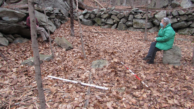
In the picture above Bill and Polly Midgely are chatting in the sacred area. Notice the two staffs near them. They mark water veins.


What is so interesting about the water veins pictured above is that they both emanate or begin close to each other. The water vein marked by the white staff begins on the right side and the water is traveling to the left. It is very weak, a trickle.

The red  striped staff marks a water vein that begins towards the top of the picture close to Polly's feet. 

It is unusual to see two water veins form separately so close to each other that are not part of a larger water dome, or as the Brits call it, a blind spring.

There was a walled path not far away that I photographed but because my battery was low the pictures did not properly process.

The question is why did they build the sacred area in the shape of a horseshoe and leave one side open?

I don't have answer. At least not yet.

Continue Reading


Wednesday, February 3, 2021

Putnam County, NY Survey- Part 3--Dragon Lines

Feng Shui speaks of Dragon Lines. Powerful Energy Lines that twist and turn, curving in the land as they move forward over the landscape as if they were a snake.  Only more powerful--A Dragon. A fire breathing serpent, an almost surreal mythological image of force and power.

Take a look at the curvaceous stone wall below. It curves towards the left and then begins to bow out to the right, before turning sharply to the left in the distance.


Dragon Energy speaks to powerful telluric currents in the land. The premise is similar to the Tanric yoga concept of Kundalini Energy. A powerful source of energy that rests dormant in our root chakra at the base of our spine. Only Dragon Lines reside in the earth.

The stone wall below has a gentler curve to it.


The curving stone walls were very reminiscent of similarly curved  stone walls we found on the other side of the Hudson River a little farther north in the Catskills.

Stone Structures--Hudson Valley/ Catskills Part 2 Dragon Lines

What is even more amazing is that these stone walls were constructed thousands of years ago and are still standing. Amazing.

A Dragon is a powerful image, as are the telluric currents of  a Dragon lin.

Continue Reading

Putnam County, NY Survey- Part 4--A Strike Point